7-Lakes Hike


- 3:00 h
- 8.14 km
- 291 m
- 775 m
- 2,074 m
- 2,749 m
- Difficulty: medium
- Start: Top station Furggulti chairlift (2562 m)
- Destination: Flesche (2068 m)
Panoramic hike past the Bellwald mountain lakes:
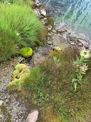
Who can keep their feet in the icy cold water the longest? The approximately 4-hour, leisurely hike to the mountain lakes is also fun for children. There are repeated opportunities for water play. The start is at the top station of the Furggulti chairlift. Then an exciting path leads to Wirbulsee, Lengsee, and Brusee. From Brusee, the path leads back to Mittelsee and Spilsee. Via the Unnera irrigation channel, you continue to Fleschensee. Here you can alternatively walk to Gasse or take the chairlift back. At the nature and recreation park, you can relax by the lake after the endurance hike.
See also
Bellwald tourism
Village
CH-3997 Bellwald
Tel.: +41 27 971 16 84
Fax: +41 27 971 41 54
E-mail: info@bellwald.ch
Internet: www.bellwald.ch

Good to know
Best to visit
Directions
The start is at the top station of the Furggulti chairlift. Then an exciting path leads to Wirbulsee, Lengsee, and Brusee. From Brusee, the path leads back to Mittelsee and Spilsee. Via the "Unnera" irrigation channel, you continue to Fleschensee. There you have the option to walk to Gasse or take the chairlift back. At the nature and recreation park, you can relax by the lake after the enduring hike.
Furggulti - Wirbulsee - Lengsee - Brusee - Honeggerhorn - Mittelsee - Spilsee - Richinen middle station
Equipment
We recommend:
- Good footwear
- Weather-dependent clothing: always carry a waterproof vest
- Headwear
- Sunscreen
- Water bottle
- Picnic
- Camera
- Binoculars (optional)
- Walking poles (optional)
- Printout of the hiking trail (click "Print" to download)
For certain hikes:
- Swimsuit
Directions & Parking facilities
Additional information
DE: View this route on SwitzerlandMobility:
No. 190 7-Lakes Hike Bellwald
https://www.schweizmobil.ch/de/wanderland/routen/route-0190.html
Literature
Get the Valais/Wallis hiking map to discover the best hikes in the region.
The Bellwald tourism office provides you with information material and brochures for hiking in the destination.
Author´s Tip / Recommendation of the author
The chairlift ride is included in the guest card during summer
Safety guidelines
The use of hiking trails and information on this website is at your own risk. Local conditions may cause changes to the route. Valais/Wallis Promotion assumes no responsibility for the accuracy and completeness of the information on this website.
For all hikes:
Carry a map with you. Download the complete description of the hiking trail with a large-scale map by clicking "Print" at the top right of the page.
Use only marked hiking trails and observe all signs and instructions – for your own safety, the protection of grazing animals, and respect for wildlife.
Close gates after passing through.
Behave considerately towards other trail users, plants, and animals.
For mountain hikes:
Carry additional sun protection. UV rays at high altitudes can be very strong, even in cloudy weather.
Plan your hike carefully: consider the required fitness level of all participants, weather forecasts, and seasonal dependencies.
Weather conditions in the mountains can change very quickly and without warning. Proper clothing and sufficient provisions (food and drink) are very important. In unsettled weather, it is better to turn back early.
For high alpine hikes:
Inform your family about your hiking route. If possible, avoid being alone.
Do not venture onto glaciers without a mountain guide.
Observe warning signs indicating hazards at riverbanks, along waterways below dams and reservoirs: water levels can rise quickly and without warning.
Preparation for a hike https://www.valais.ch/de/aktivitaeten/wandern/vorbereitung-auf-eine-wanderung
Persons undertaking this activity based on information on this website do so at their own risk. Local conditions may cause route changes and increased danger from natural hazards. We assume no responsibility for the correctness of the information or for conditions under which the activity is carried out. In doubt, please contact the destination in advance.
Map
Nearby


